
UAS Best Practices for Rumney Marsh
Rumney Marsh Conservancy developed this field guide to support responsible, low-disturbance UAS use for environmental monitoring.
This guide is intended for RMC pilots and authorized volunteers conducting environmental monitoring on behalf of Rumney Marsh Conservancy. It is not general guidance encouraging public or recreational UAS use in Rumney Marsh. Because the marsh contains sensitive wildlife habitat, members of the public should avoid recreational drone flights in sensitive areas, particularly near nesting, feeding, roosting, or concentrated wildlife activity. Anyone interested in assisting with UAS documentation should contact RMC to discuss appropriate training, coordination, and monitoring needs before flying.
Uncrewed aircraft systems, commonly called UAS or drones, are valuable tools for environmental monitoring in Rumney Marsh. They allow RMC to document tidal restrictions, tide gates, culverts, erosion, vegetation, flooding patterns, debris, restoration needs, and landscape changes over time. In many cases, UAS can also reduce the need for people to enter sensitive wetland areas on foot.
At the same time, drones could potentially disturb wildlife if they are flown too low, too close, too abruptly, or during sensitive periods. This guide reflects RMC’s own field-developed best practices for responsible UAS use in Rumney Marsh. It is not a legal document, permit, or formal standard operating procedure. It does not replace FAA rules, landowner requirements, state regulations, local ordinances, permits, or site-specific restrictions.
RMC welcomes input from wildlife biologists, birders, agency staff, aviation professionals, researchers, and marsh users.
“The basic principle is simple: collect the information needed while flying no lower, no closer, no faster, and no longer than necessary.”
1. Plan the Flight Around the Marsh
UAS flights in Rumney Marsh should be planned around the site conditions first, not the aircraft. Before launch, the pilot should understand the purpose of the flight, the minimum data needed, the tide stage, the expected wildlife conditions, the safest launch location, and the least disruptive route to complete the mission.
RMC flights should generally be limited to documentation, monitoring, mapping, inspection, and education. UAS should never be used to pursue wildlife, provoke a reaction, check whether a nest is active, or obtain close-up wildlife imagery. If wildlife becomes the subject of the flight rather than an incidental observation, the flight should be reconsidered.
The pilot should also consider whether the same information can be collected from a higher altitude, from a different angle, from a public vantage point, or with a longer camera view. A good flight is not the closest possible flight. It is the flight that collects useful information with the least practical disturbance.
2. Altitude and Airspace
For routine marsh transit and general environmental documentation, 100 feet above ground level should be treated as a practical floor, not a target altitude. When conditions allow, 150 feet or higher is preferred because it provides additional buffer from wildlife while still supporting most survey, mapping, and documentation needs.
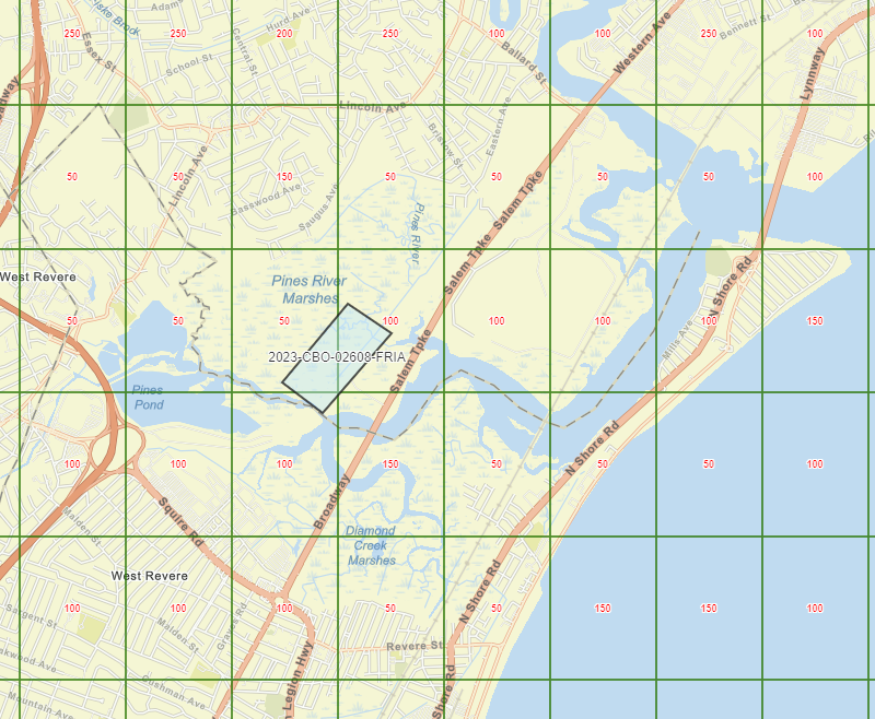
FAA’s LAANC grid for Rumney Marsh as of July 2026.
Most broad marsh documentation can be completed from approximately 150 feet. This includes vegetation views, photogrammetry, digital elevation modeling, creek alignments, ditch networks, erosion context, flooding patterns, and landscape-scale imagery. Higher altitude should be used when image quality, airspace authorization, weather, visual line of sight, and mission purpose allow.
Some work does require lower altitude. Tide gates, culverts, bridge openings, debris obstructions, outfalls, bank conditions, and other fixed infrastructure may need closer inspection. In those cases, RMC may descend substantially lower, including to approximately 20 feet, but only for a specific inspection need and only after confirming that the descent is unlikely to disturb wildlife.
Before descending below routine survey altitude, the pilot should pause at a higher altitude, establish a stable hover, use the camera and zoom to inspect the area, and look carefully for birds, mammals, nests, roosting activity, feeding activity, or other wildlife use. Descent should be slow, deliberate, and limited to the minimum altitude and duration needed. The aircraft should not descend directly over wildlife, mudflats, sandbars, marsh edges, wrack lines, creek banks, or suspected nesting areas.
Rumney Marsh is also located in controlled airspace where LAANC grid altitudes vary across the marsh area. Some areas may have grid ceilings as low as 50 feet, while nearby areas may allow 100 to 150 feet depending on location. The lower-altitude grid areas should be treated as more restrictive from an airspace-planning perspective. RMC has experience manually coordinating controlled-airspace approvals where automated LAANC approval is insufficient for a mission.
3. Launch and Recovery
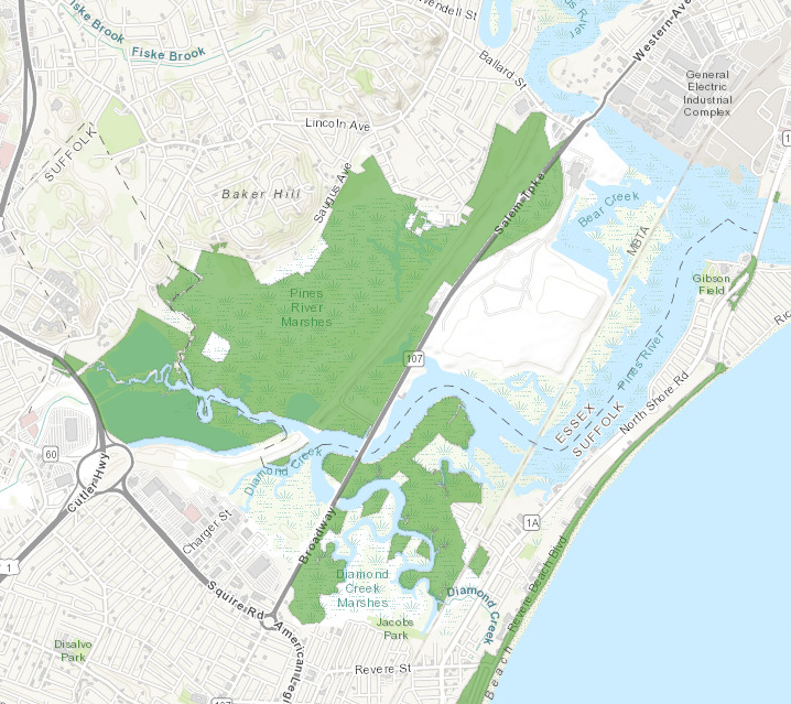
RMC does not launch or recover UAS from DCR property, shown here in green.
Launch and recovery locations should be selected based on safety, legal compliance, visual line of sight, wildlife conditions, public use, and the needs of the specific mission. The best launch point is not necessarily the closest point to the target. It is the compliant location that allows the pilot to maintain control, visibility, separation from wildlife and people, and a safe route to and from the mission area.
RMC pilots should comply with all applicable federal, state, and local requirements related to launch, recovery, and operation.
Among many other statutes, DCR property is subject to 302 CMR 12.04(28)(g), and RMC’s practice is that launch or recovery should not occur from DCR-owned property unless DCR has expressly authorized it or an emergency requires it.
Non-DCR state-owned property should not automatically be treated as subject to 302 CMR 12.04, but pilots should still confirm ownership, access, posted restrictions, and site-specific requirements before selecting a launch location.
After takeoff, the pilot should immediately, or as soon as practical, ascend smoothly and promptly to the planned operating altitude. The aircraft should not linger at low altitude near the launch area unless required for safety, system checks, obstacle avoidance, or airspace limitations.
“Unless authorized by a special use permit issued in accordance with 302 CMR 12.17(2), no person may: Except in an emergency, bring, take off, land or cause to descend on DCR property any airplane, helicopter, sea plane, so-called ultra-light aircraft, or any other apparatus.”
4. Movement, Descent, and Flight Path
UAS movement in Rumney Marsh should be smooth, predictable, and conservative. Rapid climbs, dives, sharp turns, aggressive acceleration, and abrupt directional changes are not necessary for documenting marsh conditions, tide gates, culverts, vegetation, erosion, flooding, or restoration features. These maneuvers should be avoided except where needed for safety, collision avoidance, loss-of-control prevention, wildlife avoidance, or another emergency condition.
Descending toward a target should be treated as one of the most sensitive parts of a flight. A descending aircraft can become louder, more visually obvious, and more threatening to wildlife. Before descending, the pilot should hover at a higher altitude and observe the area carefully. If wildlife is visible in the immediate target area, the mission should be modified, postponed, or abandoned.
Staying over open water or following river corridors can sometimes be a lower-disturbance way to reach a target area while maintaining separation from high marsh, nesting habitat, and trail users. This approach can be useful along the Pines River, Saugus River, and other channels where the route supports visual line of sight and mission objectives.
Flying over water does not eliminate disturbance risk. Birds may be using sandbars, mudflats, creek banks, exposed flats, wrack lines, pilings, bridge structures, and shallow-water feeding areas. Pilots should remain alert to these features and avoid treating open water routes as automatically clear.
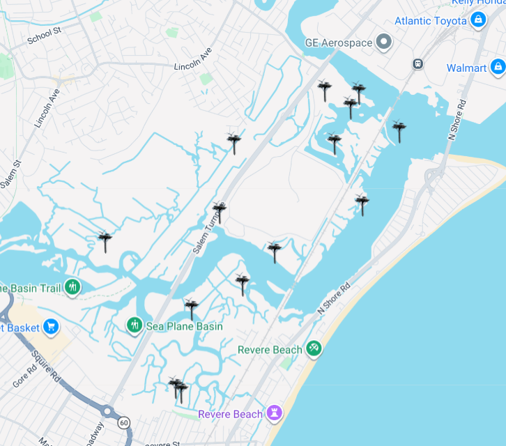
Essex County Greenbelt’s interactive Osprey nesting map - July 2026
5. Wildlife Awareness
The pilot should be familiar with Rumney Marsh geography before flying. This includes major creeks, pannes, mudflats, high marsh areas, ditch networks, tidal restrictions, upland edges, osprey platforms, bridges, public trails, roads, rail corridors, and areas where birds commonly feed, perch, nest, or roost.
Extra caution should be used during spring migration, nesting season, periods when osprey platforms or other nests are active, fall migration, winter periods when birds may be conserving energy, and high tide roosting periods when birds may be concentrated on limited dry ground.
Flooding patterns are especially important in a salt marsh. Areas that stay dry during normal high tides may be more likely to support successful nesting or resting wildlife. Wrack lines, ditch banks, elevated marsh, exposed mudflats, sandbars, and creek edges should all be treated as potentially sensitive depending on season and tide stage.
Known nesting structures and repeated wildlife-use areas should be treated as avoidance zones unless the specific purpose of the flight is authorized wildlife monitoring conducted with appropriate expertise and precautions. Rumney Marsh Conservancy uses ECGA’s Osprey platform map as a resource: https://www.ecga.org/conservation/osprey/interactive-nest-map.
6. If Wildlife Reacts
The pilot and observer should watch for signs that wildlife is reacting to the aircraft. These may include birds flushing, alarm calling, wing-flapping, leaving a perch, leaving a nest or platform, mobbing or diving at the aircraft, interrupting feeding, shifting position as the drone approaches, or otherwise moving away from the aircraft.
If disturbance occurs, the pilot should stop any descent, increase separation, and leave the area by the safest route. Depending on the behavior observed, the mission should be modified, moved, or aborted. The pilot should record the location, altitude, behavior observed, and corrective action taken so future flights can be adjusted.
“As far as RMC is concerned, if wildlife reacts, the mission is no longer worth it.”
7. Infrastructure Inspection
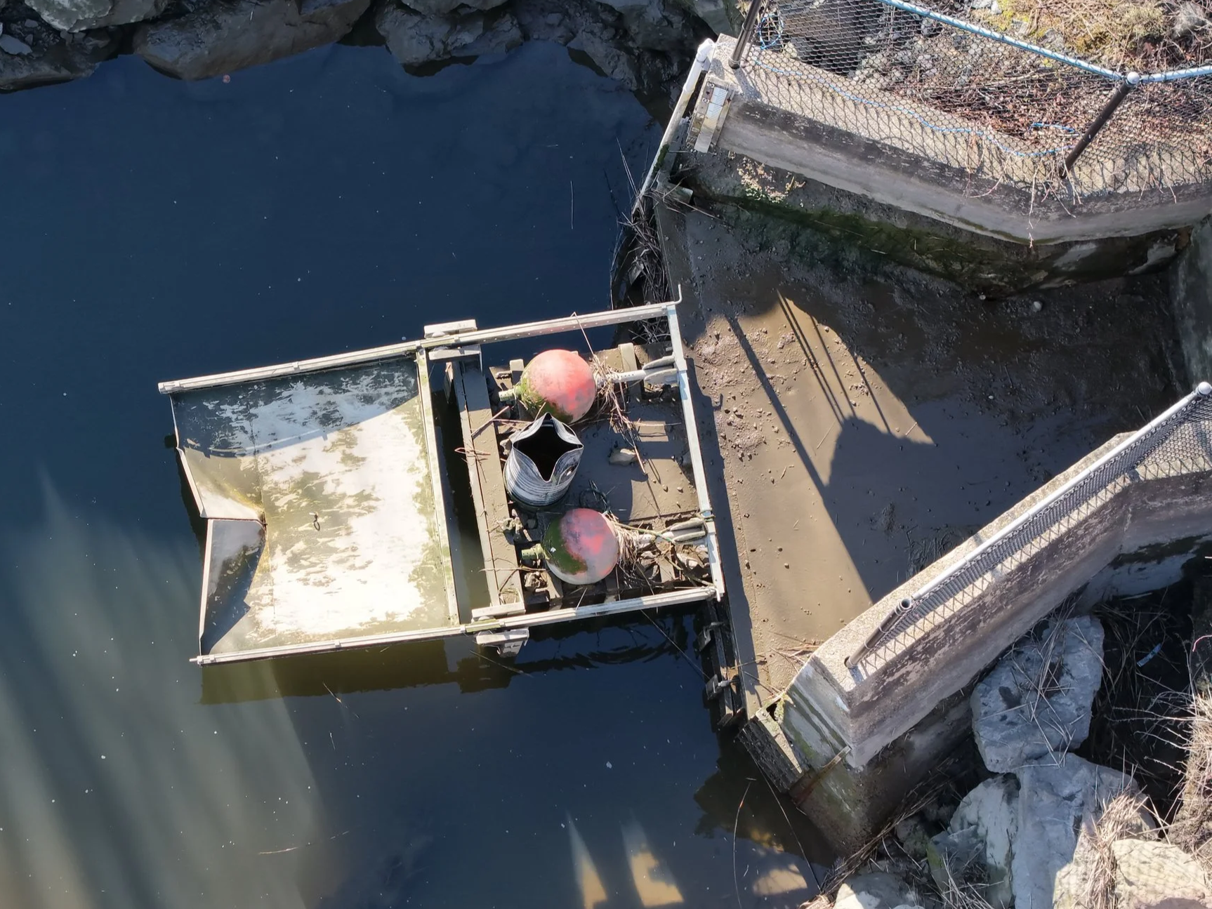
Tide gates, culverts, bridge openings, ditch obstructions, and outfalls are legitimate UAS documentation targets in Rumney Marsh. These structures can be difficult or unsafe to inspect from the ground, especially during high tides, poor footing, greenhead season, or after storms.
Infrastructure flights may require lower altitude than general marsh documentation. When low-altitude inspection is necessary, RMC should approach the structure from the least sensitive direction, use open-water routes where practical, hover at a higher altitude first, check nearby banks and exposed areas for wildlife, collect the needed imagery efficiently, and return to a higher altitude promptly.
Low-altitude infrastructure inspection should be understood as a limited documentation tool, not a general operating style.
8. Public Use and Visual Line of Sight
Rumney Marsh is also used by walkers, cyclists, anglers, paddlers, birders, photographers, nearby residents, agency staff, and maintenance crews. UAS operations should avoid unnecessary flight over people, hovering near people or homes, interfering with trail users, or creating public concern where a safer or less disruptive approach is available.
Visual line of sight is especially important in Rumney Marsh because the landscape includes bridges, roads, rail corridors, utility structures, birds, helicopters, low-flying aircraft, and rapidly changing visibility over open marsh.
The launch point should support the full mission, not only takeoff. If visibility, orientation, signal strength, weather, wind, or public conditions become marginal, the mission should be ended.
9. Flight Logging and Review
For RMC-related flights, the pilot should maintain a basic flight log. The log should include the date, time, pilot, launch location, mission purpose, authorization status if applicable, typical altitude, lowest altitude used and reason for descent, tide stage, weather, wildlife observed, any disturbance response, corrective action taken, and notes for future flights.
Over time, these logs can help RMC refine its practices for Rumney Marsh rather than relying only on general guidance from other habitats. This guide should be treated as a living document and revised based on field experience, scientific literature, agency feedback, and input from people familiar with Rumney Marsh.
10. Short Field Version
Fly only with a purpose. Use the highest practical altitude. Use lower altitude only for specific inspection needs, such as tide gates or culverts. Hover and observe before any descent. Do not descend over wildlife, mudflats, sandbars, nests, platforms, or feeding areas. Launch only from compliant locations with proper visual line of sight. Do not launch or recover from DCR property without express authorization or emergency need. Ascend immediately, or as soon as practical, after takeoff. Move smoothly, not abruptly. Stay over river corridors when appropriate, but still watch for wildlife using mudflats, sandbars, banks, and shallow water. If wildlife reacts, leave the area. If birds flush, abort the mission in that location. Document what happened and adjust future flights.
Sources consulted
This guide draws from RMC field experience, FAA UAS guidance, Massachusetts DCR park and recreation rules, U.S. Fish and Wildlife Service wildlife guidance, and published literature on UAS disturbance to birds and wildlife. Relevant topics reviewed include FAA controlled-airspace authorization, UAS facility map and LAANC grid altitudes, Part 107 operating requirements, drone disturbance effects on birds and wildlife, nesting bird sensitivity, and the use of UAS for environmental monitoring.
