What Is LIDAR and Why Does It Matter for Rumney Marsh?
If you have never seen a LIDAR map before, this is your first look at one! LIDAR stands for Light Detection and Ranging. It works by sending thousands of laser pulses toward the ground each second. Each pulse reflects back to the sensor, and the system calculates the exact distance. When you combine millions of these returns, you get a precise three dimensional model of the landscape.
Unlike regular aerial photography, LIDAR can pick up extremely small changes in elevation. It can read through vegetation. It can reveal hidden features that the eye cannot see. This makes it an incredibly powerful tool for studying salt marshes, which depend on subtle elevation differences for healthy tidal flow and habitat.
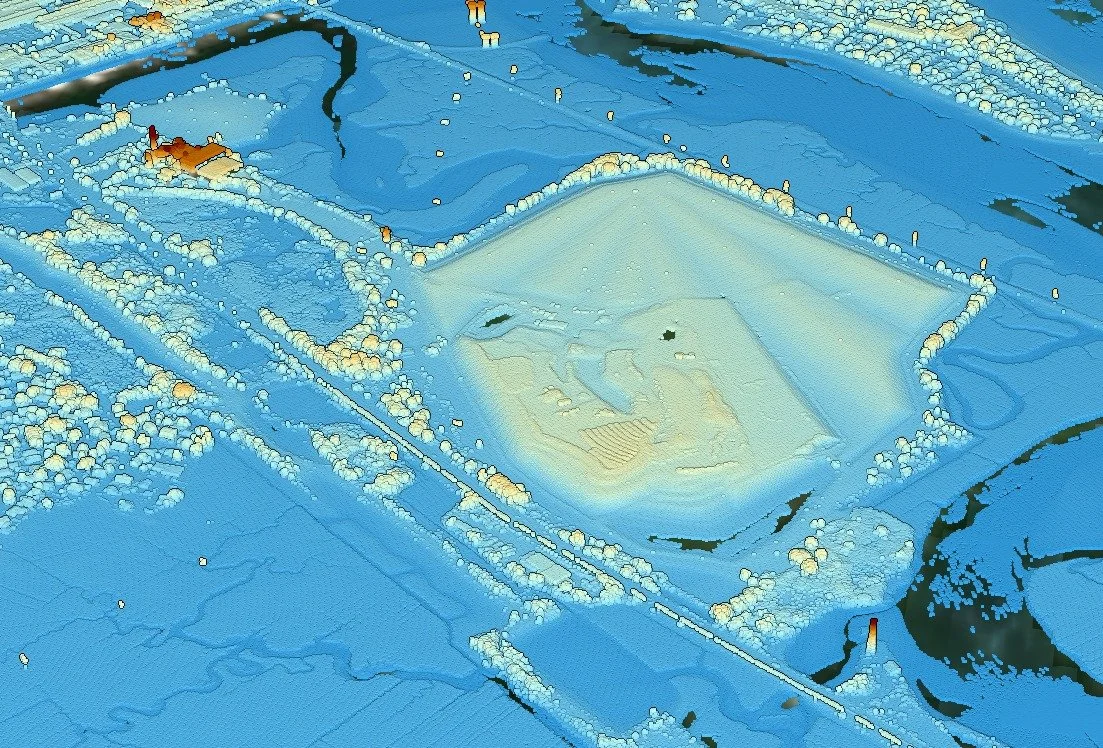
Below is a LIDAR view of the Saugus incinerator and ash monofill from USGS. The tall mound you see is the monofill rising roughly 50 feet above sea level. When you remove vegetation and look only at elevation, the shape of the land becomes obvious. The steep fill contrasts sharply with the flat marsh around it. You can also see old channels, berms, and altered flow paths that have developed over decades of construction and dumping.
This matters because Rumney Marsh is sensitive to even small changes in height. A few inches can determine whether an area becomes healthy high marsh, flooded low marsh, or open water. LIDAR shows:
• where the marsh is sinking or rising
• where channels are filling in or shifting
• how storm events reshape the surface
• which areas are most vulnerable to sea level rise
• how artificial structures interrupt natural flow
LIDAR also helps us understand how built infrastructure affects water movement. Roads, berms, and filled areas show up immediately. You can trace culverts, raised causeways, and historic alterations that still influence the marsh today.
Rumney Marsh Conservancy is developing a drone-based photogrammetry and digital surface modeling program, due to the cost of LIDAR equipment. Our goal is simple. Provide the community with high resolution, up to date data on how the marsh is changing. With better elevation information, we can support restoration work, identify problem areas sooner, and advocate with real measurements instead of assumptions.
Credit to USGS for the LIDAR imagery shown here.